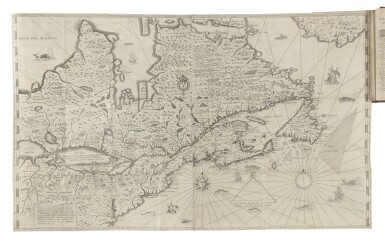
CHAMPLAIN, SAMUEL DE. Les Voyages du Sieur de Champlain Xaintongeois, Capitaine ordinaire pour le Roy, en la marine. Divisez en deux livres. Ou, Journal tres-fidele des observations faites és descouvertures de la Nouvelle France. Paris: chez Jean Berjon, 1613. 4to, contemporary limp vellum, spine with later gilt lettering, remains of ties, skilfully repaired 7-inch tear and one small marginal repair to the large folding map, 4-inch repair to fol. N3 (waterstained), touching approximately 12 letters of the recto and 6 of the verso, fols. 2E2 and 2F4 each with a tiny burn-hole, affecting respectively 2 and 4 letters, tiny tear to lower corner of title-page, other lower corners bent, outer edges of most of the smaller folding maps and plates creased, a few marginal paper defects, top edges of the last 3 leaves frayed and dampstained, repair to lower flyleaf, paper slightly browned, scattered foxing, occasional marginal soiling . THE SECOND PUBLISHED ACCOUNT OF CHAMPLAIN'S VOYAGES, 2 parts in one, containing the relations of four voyages to America made between 1604 and 1613, WITH THE RARE FOLDING MAP "CARTE GEOGRAPHIQVE DE LA NOUVELLE FRANSE," sheet: 466 x 764 mm. (18 3/8 x 30 1/4 in.) , 7 smaller folding maps (the map facing p. 160 in the second state), 3 folding plates, 13 copper engravings in the text, one woodcut diagram, woodcut head- and tail-pieces and initials, the error in the illustration on p. 9 corrected. "The volume deals very fully with the natural history of the country, its soil and products, and is especially minute in its description of the manners, customs, and habits of the Indians. In this edition the text is much fuller than in that of 1632..." (Church). The large folding map, which is lacking in most copies, is "essential to any large collection of maps of the Great Lakes, Champlain being the first to give an indication of a chain of Great Lakes connected to the St. Lawrence," (R.V. Tooley, The Mapping of America , London 1980, p. 311). Lake Ontario is described as a "Lac Contenant 15 journées des canaux des sauvages"; a second huge lake at the very left of the map, captioned "grand lac contenant 300 lieux de long," is possibly a composite of the other great lakes. The New England section, based on information gathered during three voyages made under the direction of the French colonist and fur trader Pierre du Gua de Monts, is the first accurate delineation of the New England coast. "It is also the first map of this coast in which any attempt was made to lay down its latitude and longitude"--Church 360; Sabin 11835; Lande 116; Alden 613/30; JCB (3) II: 93; Streeter sale VI, 3630. An exceptionally fine copy of a book rarely found complete. Provenance : Contemporary ownership inscriptions on front pastedown and front flyleaf, one or two early corrections and marginal doodles.
CHAMPLAIN, SAMUEL DE. Les Voyages du Sieur de Champlain Xaintongeois, Capitaine ordinaire pour le Roy, en la marine. Divisez en deux livres. Ou, Journal tres-fidele des observations faites és descouvertures de la Nouvelle France. Paris: chez Jean Berjon, 1613. 4to, contemporary limp vellum, spine with later gilt lettering, remains of ties, skilfully repaired 7-inch tear and one small marginal repair to the large folding map, 4-inch repair to fol. N3 (waterstained), touching approximately 12 letters of the recto and 6 of the verso, fols. 2E2 and 2F4 each with a tiny burn-hole, affecting respectively 2 and 4 letters, tiny tear to lower corner of title-page, other lower corners bent, outer edges of most of the smaller folding maps and plates creased, a few marginal paper defects, top edges of the last 3 leaves frayed and dampstained, repair to lower flyleaf, paper slightly browned, scattered foxing, occasional marginal soiling . THE SECOND PUBLISHED ACCOUNT OF CHAMPLAIN'S VOYAGES, 2 parts in one, containing the relations of four voyages to America made between 1604 and 1613, WITH THE RARE FOLDING MAP "CARTE GEOGRAPHIQVE DE LA NOUVELLE FRANSE," sheet: 466 x 764 mm. (18 3/8 x 30 1/4 in.) , 7 smaller folding maps (the map facing p. 160 in the second state), 3 folding plates, 13 copper engravings in the text, one woodcut diagram, woodcut head- and tail-pieces and initials, the error in the illustration on p. 9 corrected. "The volume deals very fully with the natural history of the country, its soil and products, and is especially minute in its description of the manners, customs, and habits of the Indians. In this edition the text is much fuller than in that of 1632..." (Church). The large folding map, which is lacking in most copies, is "essential to any large collection of maps of the Great Lakes, Champlain being the first to give an indication of a chain of Great Lakes connected to the St. Lawrence," (R.V. Tooley, The Mapping of America , London 1980, p. 311). Lake Ontario is described as a "Lac Contenant 15 journées des canaux des sauvages"; a second huge lake at the very left of the map, captioned "grand lac contenant 300 lieux de long," is possibly a composite of the other great lakes. The New England section, based on information gathered during three voyages made under the direction of the French colonist and fur trader Pierre du Gua de Monts, is the first accurate delineation of the New England coast. "It is also the first map of this coast in which any attempt was made to lay down its latitude and longitude"--Church 360; Sabin 11835; Lande 116; Alden 613/30; JCB (3) II: 93; Streeter sale VI, 3630. An exceptionally fine copy of a book rarely found complete. Provenance : Contemporary ownership inscriptions on front pastedown and front flyleaf, one or two early corrections and marginal doodles.
.jpg)
.jpg)


.jpg)


Try LotSearch and its premium features for 7 days - without any costs!
Be notified automatically about new items in upcoming auctions.
Create an alert