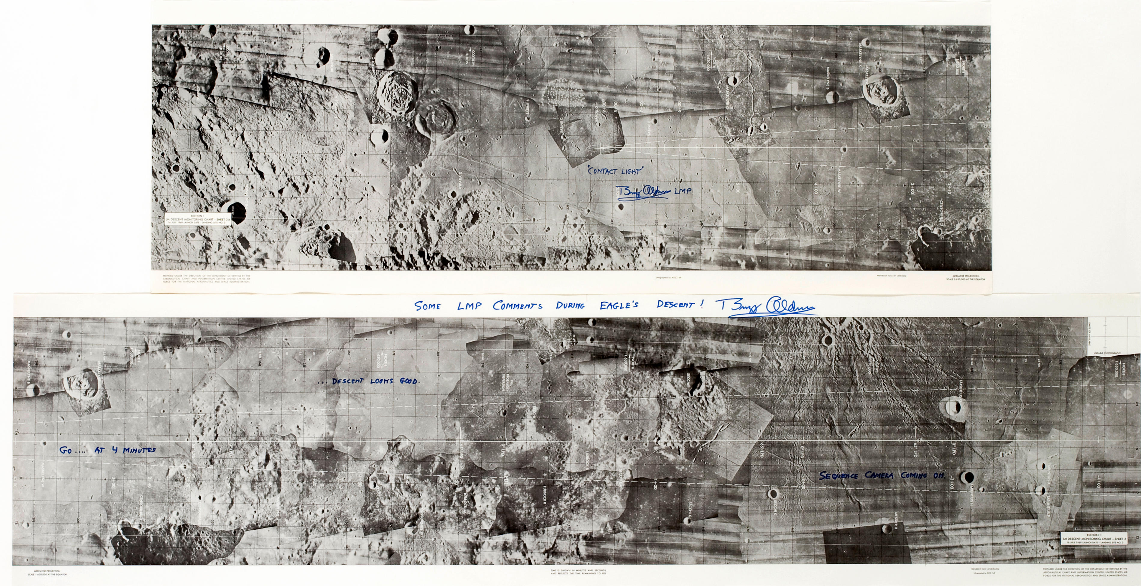
THE FLIGHT PATH TO TRANQUILITY BASE – LM Descent Monitoring Chart - Sheet 2, 16 July 1969 Launch Date – Landing Site No. 2 and LM Descent Monitoring Chart - Sheet 3A, 16 July 1969 Launch Date – Landing Site No. 2. [Manned Spacecraft Center, 1969.] The ground track which Armstrong and Aldrin followed to land on the moon, signed by Buzz ALDRIN who has marked the landing site with an “X.” The lunar surface at the Sea of Tranquility was charted from Lunar Orbiter photography collected just three years earlier. There is a wide descent path marked with dashed outer lines and a solid center line at the chart’s horizontal mid-point representing the planned ground track. This solid line has time marks starting at 4 minutes denoting time marks in one minute intervals before the PDI (Power Descent Initiation) engine burn by Eagle . At the PDI point on the chart, Eagle’s large descent engine ignited and started to lower Armstrong and Aldrin to the lunar surface. Time marks occur every 20 seconds as the burn progresses toward the landing ellipse. After 3 minutes, time marks are made every minute. The last time mark is at plus 9 minutes, ending near the center of the ellipse, with the full PDI expected to be around 11 minutes. Due to numerous craters and boulders, Armstrong had to manually fly over these obstacles and find a more suitable area to land. This required nearly one minute more of flying time with his final touchdown point almost 4 miles from the ellipse center point and 12.5 minutes after starting PDI. Armstrong had approximately 30 seconds of fuel remaining at landing. Craters are individuated including those named by astronauts, such as Gemini Ridge, Apollo Ridge and Rille, Cape Venus, Mt. Marilyn (for Apollo 8 and 13 astronaut Jim Lovell’s wife), Weatherford (for Apollo 10 astronaut Tom Stafford’s home town in Oklahoma), plus Last Ridge and Cat’s Paw near the landing area ellipse. Chart on two connected sheets, 11 by 84 inches overall. First edition.
THE FLIGHT PATH TO TRANQUILITY BASE – LM Descent Monitoring Chart - Sheet 2, 16 July 1969 Launch Date – Landing Site No. 2 and LM Descent Monitoring Chart - Sheet 3A, 16 July 1969 Launch Date – Landing Site No. 2. [Manned Spacecraft Center, 1969.] The ground track which Armstrong and Aldrin followed to land on the moon, signed by Buzz ALDRIN who has marked the landing site with an “X.” The lunar surface at the Sea of Tranquility was charted from Lunar Orbiter photography collected just three years earlier. There is a wide descent path marked with dashed outer lines and a solid center line at the chart’s horizontal mid-point representing the planned ground track. This solid line has time marks starting at 4 minutes denoting time marks in one minute intervals before the PDI (Power Descent Initiation) engine burn by Eagle . At the PDI point on the chart, Eagle’s large descent engine ignited and started to lower Armstrong and Aldrin to the lunar surface. Time marks occur every 20 seconds as the burn progresses toward the landing ellipse. After 3 minutes, time marks are made every minute. The last time mark is at plus 9 minutes, ending near the center of the ellipse, with the full PDI expected to be around 11 minutes. Due to numerous craters and boulders, Armstrong had to manually fly over these obstacles and find a more suitable area to land. This required nearly one minute more of flying time with his final touchdown point almost 4 miles from the ellipse center point and 12.5 minutes after starting PDI. Armstrong had approximately 30 seconds of fuel remaining at landing. Craters are individuated including those named by astronauts, such as Gemini Ridge, Apollo Ridge and Rille, Cape Venus, Mt. Marilyn (for Apollo 8 and 13 astronaut Jim Lovell’s wife), Weatherford (for Apollo 10 astronaut Tom Stafford’s home town in Oklahoma), plus Last Ridge and Cat’s Paw near the landing area ellipse. Chart on two connected sheets, 11 by 84 inches overall. First edition.



.jpg?w=400?width=1600&quality=70)


.jpg)
.jpg?w=400?width=1600&quality=70)

Try LotSearch and its premium features for 7 days - without any costs!
Be notified automatically about new items in upcoming auctions.
Create an alert