The Property of Sir Brooke Boothby, 15th Bt., removed from Fonmon Castle, Glamorgan
Moses Pitt
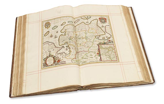
The English Atlas. Oxford: The Theatre, for Jansson in Amsterdam, 1680-[1683]
4 volumes, large folio (590 x 375mm.), engraved portrait of Charles II and engraved allegorical frontispiece in vol.1, engraved title in vols 2 and 4 (the latter laid in, with title in manuscript on overslip), printed titles in red and black in vols 1 and 2, directions to the binder leaves at end of vols 1 and 2, 167 (of 171) plain engraved maps, INCLUDING THE OFTEN WANTING LAPLANDERS PLATE, by or after Nicolaes Visscher, Jan van Loon, Johannes Janssonius, Francis Lamb and Moses Pitt, many pages in vol.1 with marginal annotations in a contemporary hand, contemporary boards, vol.1 with engraved portrait of Charles II creased and torn at lower margin, some worming to early leaves, and annotations shaved at margins, vol.3 lacking 2 text leaves before map of "Austria Archducatus", creasing, browning, and some marginal repairs throughout, textblocks coming loose from boards, extremities very rubbed
A wide-margined copy, including the rare plate of the Laplanders, and annotated in a contemporary hand in the first volume. Marginal corrections to K2, in the section of text on "Muscovy, or Russia", confirm that this annotator was a very early reader, who read the book in the year of its publication. (Here, the annotator notes that Tsar Alexei Michailovich has been succeeded by his son "Feodor [...] who reigns this prese[n]t year 1680"). Other annotations include latitudes and longitudes of places described, as well as some rather fastidious observations about the accuracy of the text—for instance, noting the contradictory characterisation of the Polish people as "more given to sloth then gluttony or drunkenness" ("X a contradiction to what is said below"), on the one hand, and "alwaies... much given to drunkenness" ("X a contradiction to what is said above"), on the other hand.
The work comprises two world maps and a map of the North Pole, with the remaining sheets covering Northern and Eastern Europe, particularly Germany and the Low Countries, all based on Dutch cartography. Moses Pitt had planned to produce a twelve-volume atlas in the Blaeu-Janssonius traditon, however this project failed after only 4 volumes were published. He was imprisoned for debt and published The Cry of the Oppressed (1691) about the prison condition. This atlas was almost entirely compiled from old plates acquired from the plate stock of Joannes Janssonius. The two world maps are: J. van Loon's Orbis terrarum nova et accuratissima tabula [Shirley 439] and Pieter van den Keere's Nova totius terrarum orbis geographica ac hydrographica tabula in the revised Janssonius (post 1620) state [Shirley 504].
LITERATURE:National Maritime Museum Catalogue 3, 410; Shirley, British Library T.Pitt-1a


Try LotSearch and its premium features for 7 days - without any costs!
Be notified automatically about new items in upcoming auctions.
Create an alert