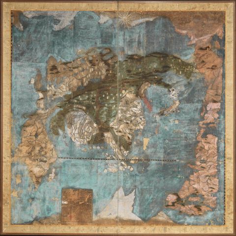
CHINA - [Map of the 13 Provinces of the North and South Capitals (China)], the general title [Report of the culture and internal trade in renchen year]. Beijing: [ca. 1712]. Manuscript map of the administrative divisions and geography of China, black ink and colours, on 20 sheets of native paper, joined and backed, overall 1850 x 1640mm. The map surmounted by general title and descriptive geographical text, lower panel with descriptive text of administrative functions, sizes, populations and productions for each of the 15 provinces of China (Beijing, Jiangnan, Shandong, Shanxi, Henan, Shaanxi, Zhejiang, Jiangxi, Hunan, Sichuan, Fujian, Guangdong, Guangxi, Yunnan, Guizhou), this text signed and dated Kangxi, the month of the dragon boat festival, 5th day of the 5th lunar month, also with three authorisation stamps at lower left corner. The map is orientated north, the borders defined by the Great Wall to the north, seas to the south and east and the Hwang (Yellow) river to the west, above the Great Wall are symbolic representations of the principal mountains of China with short descriptive texts. The provincial and administrative district boundaries are carefully drawn, the provinces coloured in blue, yellow and white washes, mountains in green, rivers in blue, seas with wave symbols, the main towns clearly marked with squares and circles of varying size indicating importance, each named and described. (The map carefully laid down and with neat margin extensions, several old worm holes.) A fine and rare example of a Chinese administrative map drawn up in Beijing, probably for use at provincial administrative level. The general title describes the postion of trade in China in the renchen year in reign of Kangxi (1662-1722), ie. for the year 1712. It is likely that this particularly map was therefore drawn up soon after 1712, as one of a number of copies for distribution to the 15 provincial capitals. Geographically the image and design of the map is derived from Matteo Ricci's lost map of 1584, now only known through a unique copy of Liang Chou's woodcut map of 1593 (sold in the Robinson collection, part II, Sotheby's 22nd November 1988 lot 85). This map also includes the descriptive sections on the 15 provinces (2 were considered outside old China being near Tibet), and descriptive texts on the mountains. This map however does not include the border 'islands' around China which represented the outside world. Interestingly at the same time as this map was being drawn up the Jesuit survey of China was being completed by 1717, providing a detailed European approach to Chinese cartography rather than the traditional chino-centric version represented in this example. Maps such as the present example provided an important administrative tool for the Manchu control of the Chinese empire. cf. The History of Cartography Vol II book 2, chapter 7; Needham Science and Civilisation in China , chapter 22.
CHINA - [Map of the 13 Provinces of the North and South Capitals (China)], the general title [Report of the culture and internal trade in renchen year]. Beijing: [ca. 1712]. Manuscript map of the administrative divisions and geography of China, black ink and colours, on 20 sheets of native paper, joined and backed, overall 1850 x 1640mm. The map surmounted by general title and descriptive geographical text, lower panel with descriptive text of administrative functions, sizes, populations and productions for each of the 15 provinces of China (Beijing, Jiangnan, Shandong, Shanxi, Henan, Shaanxi, Zhejiang, Jiangxi, Hunan, Sichuan, Fujian, Guangdong, Guangxi, Yunnan, Guizhou), this text signed and dated Kangxi, the month of the dragon boat festival, 5th day of the 5th lunar month, also with three authorisation stamps at lower left corner. The map is orientated north, the borders defined by the Great Wall to the north, seas to the south and east and the Hwang (Yellow) river to the west, above the Great Wall are symbolic representations of the principal mountains of China with short descriptive texts. The provincial and administrative district boundaries are carefully drawn, the provinces coloured in blue, yellow and white washes, mountains in green, rivers in blue, seas with wave symbols, the main towns clearly marked with squares and circles of varying size indicating importance, each named and described. (The map carefully laid down and with neat margin extensions, several old worm holes.) A fine and rare example of a Chinese administrative map drawn up in Beijing, probably for use at provincial administrative level. The general title describes the postion of trade in China in the renchen year in reign of Kangxi (1662-1722), ie. for the year 1712. It is likely that this particularly map was therefore drawn up soon after 1712, as one of a number of copies for distribution to the 15 provincial capitals. Geographically the image and design of the map is derived from Matteo Ricci's lost map of 1584, now only known through a unique copy of Liang Chou's woodcut map of 1593 (sold in the Robinson collection, part II, Sotheby's 22nd November 1988 lot 85). This map also includes the descriptive sections on the 15 provinces (2 were considered outside old China being near Tibet), and descriptive texts on the mountains. This map however does not include the border 'islands' around China which represented the outside world. Interestingly at the same time as this map was being drawn up the Jesuit survey of China was being completed by 1717, providing a detailed European approach to Chinese cartography rather than the traditional chino-centric version represented in this example. Maps such as the present example provided an important administrative tool for the Manchu control of the Chinese empire. cf. The History of Cartography Vol II book 2, chapter 7; Needham Science and Civilisation in China , chapter 22.
.jpg)
.jpg)
.jpg)
.jpg)

.jpg)
.jpg)
.jpg)


.jpg)
.jpg)
.jpg)
.jpg)
Try LotSearch and its premium features for 7 days - without any costs!
Be notified automatically about new items in upcoming auctions.
Create an alert