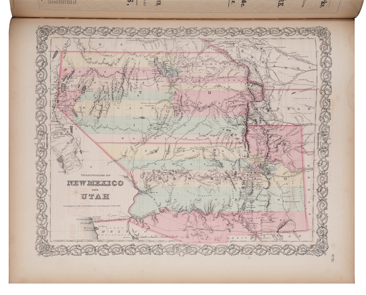
Title: Colton's Atlas of the World, Illustrating Physical and Political Geography by George W. Colton. Accompanied by Descriptions, Geographical, Statistical, and Historical, by Richard Swainson Fisher...Volume I.--North and South America, Etc. [and] Volume II.--Europe, Asia, Africa, Oceanica, Etc. Author: Colton, George Woolworth Place: New York Publisher: J. H. Colton & Co. Date: 1856 Description: 2 volumes. Vol. I with 63 plates of hand-colored lithographed maps (2 are double-page); Vol. II with 49 hand-colored plates of lithographed maps and charts . Vol. I with pictorial steel-engraved additional title page; Vol. II with steel-engraved frontispiece. 47x40 cm (18½x16), original quarter black morocco and blind-stamped brown cloth, pictorially stamped and lettered in gilt, all edges gilt. Colton's important and large "Atlas of the World" in two volumes. Volume I with U.S. maps, including a double-page Texas map with two inset plans for Galveston Bay and Sabine Lake showing roads and trails going into Mexico; Nebraska and Kanzas with an extra large Nebraska (no Montana and portions of Washington, Oregon, Minnesota, Iowa, Missouri and Wisconsin); map for the Territories of New Mexico and Utah showing Fremont's 1844-45 routes; California with an inset of San Francisco and shows Atlantic and Pacific R.R. lines; Washington and Oregon Territories with extended land mass. City plans for Boston, Philadelphia, Baltimore, Washington DC, Savannah, Charleston, Louisville, New Orleans, Pittsburgh, Cincinnati, St. Louis, and Chicago. Volume II with maps outside of the Americas, covering European countries, Australia, Arabia, Asia, Islands of the Pacific Ocean and a chart showing the mountains and rivers of the world. Signature on flyleaf, both volumes, "Mr. E M Cline's Book 1856". Provenance: Dawson's 2/84 References: P-LG 816, 6125; each with different imprint and different from this copy. Ristow, American Maps and Mapmakers, Chap.19. Lot Amendments Condition: Spine foot of Vol. I chipped and chewed, wear to spine head; otherwise very nice, clean copies. Item number: 271785
Title: Colton's Atlas of the World, Illustrating Physical and Political Geography by George W. Colton. Accompanied by Descriptions, Geographical, Statistical, and Historical, by Richard Swainson Fisher...Volume I.--North and South America, Etc. [and] Volume II.--Europe, Asia, Africa, Oceanica, Etc. Author: Colton, George Woolworth Place: New York Publisher: J. H. Colton & Co. Date: 1856 Description: 2 volumes. Vol. I with 63 plates of hand-colored lithographed maps (2 are double-page); Vol. II with 49 hand-colored plates of lithographed maps and charts . Vol. I with pictorial steel-engraved additional title page; Vol. II with steel-engraved frontispiece. 47x40 cm (18½x16), original quarter black morocco and blind-stamped brown cloth, pictorially stamped and lettered in gilt, all edges gilt. Colton's important and large "Atlas of the World" in two volumes. Volume I with U.S. maps, including a double-page Texas map with two inset plans for Galveston Bay and Sabine Lake showing roads and trails going into Mexico; Nebraska and Kanzas with an extra large Nebraska (no Montana and portions of Washington, Oregon, Minnesota, Iowa, Missouri and Wisconsin); map for the Territories of New Mexico and Utah showing Fremont's 1844-45 routes; California with an inset of San Francisco and shows Atlantic and Pacific R.R. lines; Washington and Oregon Territories with extended land mass. City plans for Boston, Philadelphia, Baltimore, Washington DC, Savannah, Charleston, Louisville, New Orleans, Pittsburgh, Cincinnati, St. Louis, and Chicago. Volume II with maps outside of the Americas, covering European countries, Australia, Arabia, Asia, Islands of the Pacific Ocean and a chart showing the mountains and rivers of the world. Signature on flyleaf, both volumes, "Mr. E M Cline's Book 1856". Provenance: Dawson's 2/84 References: P-LG 816, 6125; each with different imprint and different from this copy. Ristow, American Maps and Mapmakers, Chap.19. Lot Amendments Condition: Spine foot of Vol. I chipped and chewed, wear to spine head; otherwise very nice, clean copies. Item number: 271785


Try LotSearch and its premium features for 7 days - without any costs!
Be notified automatically about new items in upcoming auctions.
Create an alert